.jpg)
Community
About Us
Location
Chisholm Township is located in Northern Ontario approximately 3 ½ hours north of Toronto via Highways 400 and 11 North, and approximately 4 hours drive west of Ottawa via Highways 17 West and 11 South.
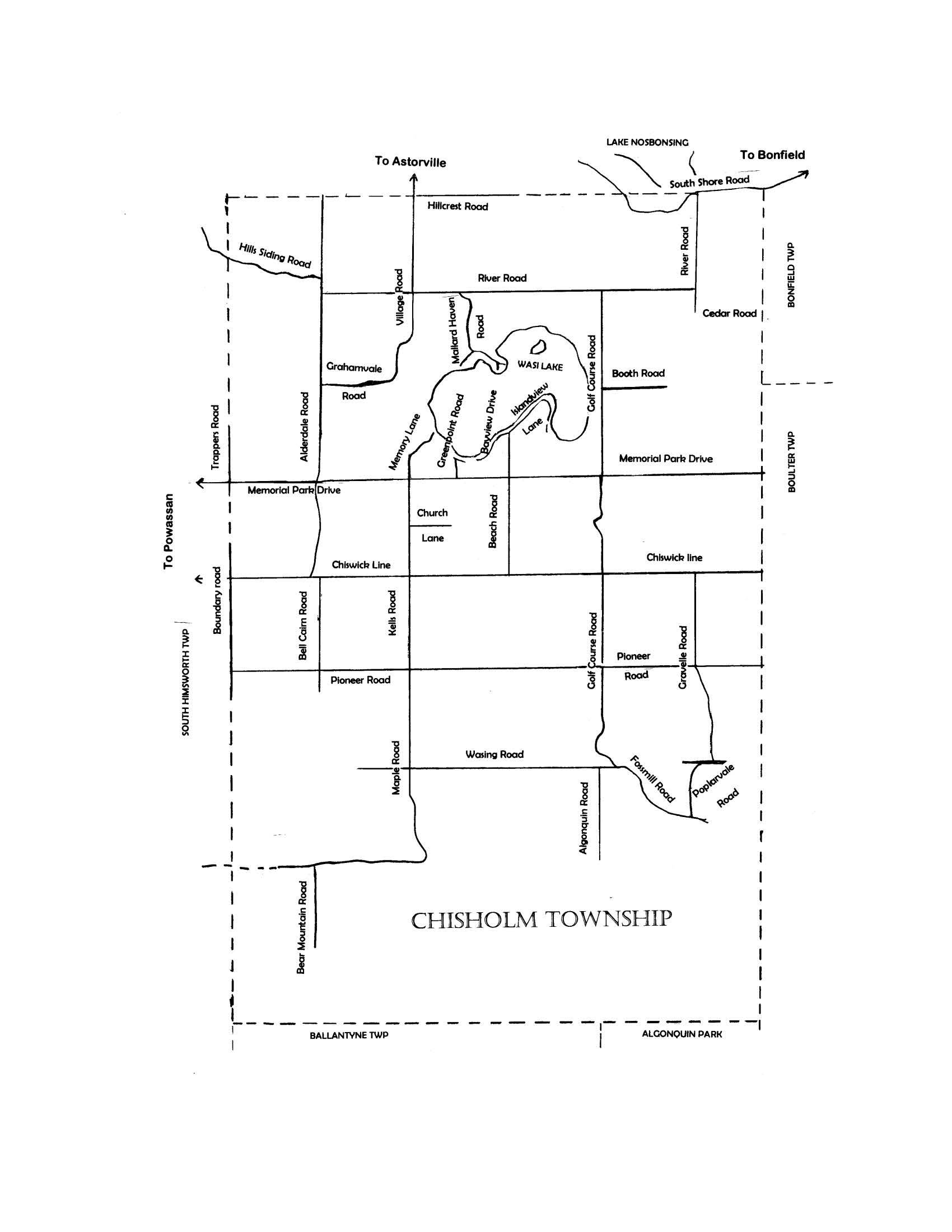
The Township is a rectangle approximately 18 kilometers long and 13 kilometers wide. The length does not run due north, but slightly to the northwest. It is bordered on the east by Boulter and Bonfield Townships, on the west by the Municipality of Powassan, on the north by East Ferris Township and on the south by Ballantyne Township and Algonquin Park.
The Township is divided into 18 concessions which run east and west, and 29 lots which run north and south. These concessions and lots are long strips of land that run the entire width and length of the Township. They are split up into individual lots that are usually 100 acres, being approximately one kilometer long and 2/5th of a kilometer wide. The township has approximately 122km of Roads, 9 Bridges and 10 Large Culverts.
Up until 1995 the roads that run east and west were identified by their concession number, and the roads that run north and south were known as side roads and identified by their lot number. In 1995 all the roads were given names.
Before the arrival of the white man, the Chisholm area was inhabited from time to time by the natives, chiefly by the Nipissing First nation. Many native artifacts have been discovered and these are displayed in the Council Chambers at the Township Office.
About 1860 the first lumbermen arrived in Chisholm and logging operations began. By this time very few natives resided in the area, and when the first white settlers arrived several years later they had all gone.
J.R. Booth, known as “Canada’s Greatest Lumberman”, established a logging depot by the Nosbonsing River, which consequently became known as Depot Creek until it was renamed. He floated the logs down the creek into Lake Nosbonsing, and then into the Mattawa and Ottawa Rivers. Over the next fifty years Chisholm was logged extensively, and except for the occasional tree, all the prime growth white pine was taken out. Booth was an aggressive entrepreneur. To extend his logging operation he dammed Wasi Lake, where it flows into the Wasi River, so that the lake would overflow into Depot Creek. For a while the Township was almost cut in two by the flood that ensued, but the government soon put a stop to his plan.
As logging declined, farming and the operation of sawmills were the chief means of subsistence.
For many years roads were little more than trails that followed the rivers or the contours of the land. Communication and socializing were limited. People survived largely by trading goods and services.
For many years roads were little more than trails that followed the rivers or the contours of the land. Communication and socializing were limited. People survived largely by trading goods and services.
Chisholm was first identified as a township when in 1880 it was surveyed into 100 acre lots, but it did not become an incorporated township until 1912 when the first council was elected. It was named after Kenneth Chisholm, who was an MPP and a successful businessman in Brampton.
In 1915, when the Canadian Northern Railway (later the CNR) was built through Chisholm, William Foster established a sawmill, with lumber yards and sidings, in the southeast corner of the Township. The operation became known as “Fosters Mill” and later simply as “Fossmill”. The village of Fossmill sprang up. It had residences, a church, a school and a boarding house, baseball diamond and a railroad station. There were movies, dances and much social activity. Many jobs were provided and farmers sold their produce to the residents of the burgeoning village.
The arrival of the railroad marked a huge step in the development of the Township. Not only was there a station at Fossmill, but one at Alderdale also and there was a stop between the two at Wasing. There was also a local train that would stop almost anywhere. Residents could now travel easily to North Bay.
The Township evolved gradually. Churches, schools and stores began to appear. In 1920 a bridge was built across the Wasi River opening up the east-west corridor along the 10th line, now known as Chiswick Line. The land became better defined as roads, bridges and fences were established. In 1934 there was a big fire in the Fossmill lumberyard and in 1936 the mill itself burned down and was never rebuilt. As a consequence the village became derelict. By this time, however, farms had become quite productive, and there was still an opportunity to make a living from the land. Sales of meat, milk, vegetables, wood and maple syrup helped to swell the family coffers.
With the advent of the automobile, roads were greatly improved and many bridges built. Decentralization began as travel to and from the Township became easy. Schools were closed and so were the train stations. The last train passed along the line in 1995. Many of the large farms have now disappeared and a movement towards hobby farms, with a small number of animals, has taken hold. People move here to get closer to nature and live a different lifestyle.
With an area of approximately 200 square kilometers and a population of about 1,200, Chisholm Township is still very much a rural community. Please enjoy it and take good care of it.
Chisholm’s history has been recorded in books entitled “Our Chisholm History” – due in part to the hard work of the History Committee of the Chisholm’s Women’s Institute. These women wanted to preserve the stories of our grand old settlers.
Volume I covers history from 1880 to 1960, with accounts of war records, school histories, and family histories as well as maps and pictures.
Fourteen years later, the History Committee produced Volume II (1880-1974), which included family histories that had not appeared in Volume I.
Then in 2000, Volume III was produced, due again to the hard work of the Women’s Institute along with a Volunteer Chisholm Heritage Committee.
These books can be viewed at local libraries or can be purchased at the Township Office for $40.00 each or all three volumes for $75.00.
Chisholm is on a high level of land that sheds water into two immense watercourses. Wasi River feeds into Lake Nipissing and thence into the great lakes and the west. Nosbonsing River feeds into Lake Nosbonsing and thence into the Mattawa and Ottawa Rivers, and the east.
The elevation varies from about 280 feet above sea level in the north to 450 feet in the south.
The Township has a variety of terrain. There are gently rolling hills and pastures, lakes and rivers, rugged rocky sections and dense forests. The high ground at the southern end is undeveloped and is known as Algonquin Highlands. A main feature of the Township is beautiful Wistawasing Lake, known locally as Wasi Lake, with its’ two public beaches and its enclave of homes and cottages. The other lake, Graham Lake, is on private property and does not have public access.
A topographical map can be purchased at Brushey’s in Powassan. Chisholm is wholly contained in map “Powassan 31 L/3”. A detailed base map showing all the lots in the Township can be viewed in the Township Office along with an aerial view of Chisholm made in about 1969.